- UK Information
- UK Guidebooks and Maps
- UK Books for counties
- West Yorkshire books and maps
West Yorkshire books and maps
Here is a list of books for West Yorkshire that you may find useful.West Yorkshire books: Maps
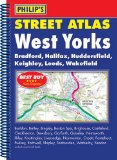
Philip's Street Atlas West Yorkshire
This street atlas of West Yorkshire gives comprehensive and detailed coverage of the region. The route planner shows all the A and B roads, and can be used when driving to get close to the destination before turning to the relevant large-scale street map.The street maps show every named road, street and lane very clearly, with major roads picked out in colour. The maps are at a scale of 3.5 inches to 1 mile. The city centres of Bradford, Halifax, Leeds and Wakefield are shown at 7 inches to 1 mile.Other information on the maps includes postcode boundaries, car parks, railway and bus stations, post offices, schools, colleges, hospitals, police and fire stations, places of worship, leisure centres, footpaths and bridleways, camping and caravan sites, golf courses, and many other places of interest.The comprehensive index lists street names and postcodes, plus schools, hospitals, railway stations, shopping centres and other such features picked out in red, with other places of interest shown in blue.
Price: £7.69
Publication: 15 Jun 2007 [Spiral-Bound]
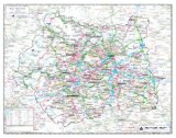
West Yorkshire County Planning Map: No. 1A
County Wall Map of West Yorkshire at a scale of 1:75,000. The map measures approximately 900 x 800mm. Part of a new series of county wall maps published by The Map Centre Press to include each county of England. These maps use the very latest mapping information from Collins Bartholomew to produce attractive and informative wall maps. The county administrative boundary is highlighted on each map and for added emphasis the mapping outside the boundary has been faded out. These maps are ideal for any county-based businesses or organisations.
Price: £19.99
Publication: 28 April 2009 [Map]

West Yorkshire Street Atlas: Leeds, Bradford, Halifax, Huddersfield, Wakefield
This spiral bound atlas of West Yorkshire includes Leeds, Bradford, Halifax, Huddersfield, Wakefield, Dewsbury and Castleford. The 172 pages of coloured street mapping extends to:
Bolton Abbey, Addingham, Ilkley, Otley, North Rigton, Wetherby, Walton, Micklefield, Fairburn, Brotherton, Knottingley, Womersley, Skellow, South Elmsall, Royston, Darton, Clayton West, Denby Dale, Holmfirth, Marsden, Todmorden, Haworth, Keighley, Steeton and Silsden.
There are large scale city and town centre maps of Leeds, Bradford, Halifax, Huddersfield and Wakefield.
Postcode districts, one-way streets and safety camera locations with their maximum speed limit are featured on the mapping.
The index section lists streets, selected flats, walkways and places of interest, place, area and station names. There is a separate list of hospitals, hospices and NHS Walk-in Centres covered by this atlas.
Price: £7.66
Publication: 2 Feb 2010 [Illustrated] [Spiral-Bound]
West Yorkshire books: Walking and Tours
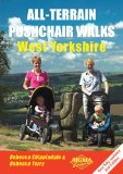
All-Terrain Puschair Walks: West Yorkshire (All-Terrain Pushchair Walks)
Price: £6.47
Publication: 1 Oct 2010
Price: £6.47
Publication: 1 Oct 2010
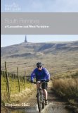
Mountain Bike Guide - South Pennines of West Yorkshire and Lancashire
"The South Pennines Mountain Bike Guidebook" introduces you to the wilderness and urban trail networks of Kirklees & Calderdale, Airedale & Wharfedale and Lancashire. New riding centres include: Stainburn, Healey Nab, Gisburn Forest and Lee Quarry that mix freely with classic Pennine riding on London Road, around Rivington Pike and on likely Moor. This guide contains 26 meticulously researched and legal routes, most with short, medium and long modular options detailing routes that can be full day epics, half day rides or a short blast. The modular design means you can choose from over 70 separate possible rides to suit the weather conditions on the day, or simply how much of a ride you fancy. Each route is accompanied by excellent, evocative photography clearly detailing what you can expect to see on route. Ordnance Survey mapping, gradient profiles, clear route descriptions and informative text make planning your ride a pleasure in your living room and routes easy to follow from your pocket, on the trail.
Price: £11.22
Publication: 1 April 2010 [Paperback]
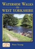
Waterside Walks in West Yorkshire
Twenty circular walks including routes around the reservoir at Addingham, the Leeds and Liverpool Canal at Bingley, the lakes in Anglers Country Park near Wakefield and Ogden Water. In full colour.
Price: £7.99
Publication: 17 Jun 2010 [Illustrated] [Paperback]
Twenty circular walks including routes around the reservoir at Addingham, the Leeds and Liverpool Canal at Bingley, the lakes in Anglers Country Park near Wakefield and Ogden Water. In full colour.
Price: £7.99
Publication: 17 Jun 2010 [Illustrated] [Paperback]
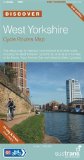
West Yorkshire Cycle Routes Map (Sustrans National Cycle Network Discover Series)
This is the Sustrans cycle routes map in the "Discover" series detailing the National Cycle Network and other routes in West Yorkshire. Amongst other highlights, the map shows the West Yorkshire Cycle Route and parts of the Way of the Roses, Trans Pennine Trail and Yorkshire Dales Cycleway. West Yorkshire is one of Britain's great metropolitan heartlands with more than two million people living in its cities, towns and villages. Over the last 25 years Sustrans has been working with local authorities and other partners to develop the National Cycle Network - this map shows the progress made, together with a multitude of other signed and recommended routes. Highlights are many but to show just how convenient and enjoyable riding your bike can be, try the following: the Airedale Greenway through Saltaire World Heritage Site; the award winning Spen Valley Greenway between Bradford and Dewsbury; out of Harrogate on the new greenway across the Nidd Gorge; and on the Wyke Beck Way in Leeds. The map shows all the railway stations where you can catch a train with your bike, or leave it parked safely. 15 inset city/town maps are shown for Ripon, Harrogate, York, Keighley, Halifax, Shipley, Hebden Bridge, Holmfirth, Selby, Leeds, Dewsbury, Barnsley, Bradford, Huddersfield and Wakefield. It features: clearly mapped traffic-free and on-road National Cycle Routes and other cycle routes; detailed inset maps of towns and cities, National Cycle Routes and linking routes; land profiles for the featured cycle routes; easy to read contours; Local Tourist Information Centre, bike shop and hire centre details; and, printed on waterproof paper.
Price: £6.29
Publication: 1 July 2012 [Folded Map] [Map]
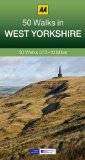
West Yorkshire: AA 50 Walks (50 Walks in)
Walking is one of Britain's favourite leisure activities, and this guide features a variety of mapped walks to suit all abilities. The book features all of the practical detail you need, accompanied by fascinating background reading on the history and wildlife of West Yorkshire, and cear mapping for ease of use. Every route has been colour coded according to difficulty. All walks are annotated with local points of interest and places to stop for refreshments. Every walk is given a summary of distance, time, gradient, level of difficulty, type of surface and access, landscape, dog friendliness, parking and public toilets.
Price: £9.99
Publication: 1 Sep 2013 [Paperback]
The West Yorkshire
books listed on this page are for your information and to help you find the books you need quickly. We do not endorse any particular books and are not responsible for the advice and information in the books listed.
The price of books, where indicated, was correct at the time the book was added to this page. Prices may have changed on the booksellers web site.