- UK Information
- UK Guidebooks and Maps
- York books and maps
York books and maps
Here is a list of books for York that you may find useful.If you plan to travel to York you may be interested in some guide books and travel books that will help you plan your stay in York and to find your way around. Click on any book for more information or to buy.
York books: Maps
A-Z York Mini Map (A-Z Mini Map)
The A-Z Mini Map series is an innovative concept that utilises large scale A-Z mapping to produce a pocket or handbag size city centre map that is both informative and user friendly.
This A-Z map of York City Centre is a full colour, double-sided, foldout mini map. Opening out to a single A3 sheet, this easy to use folding design concertinas back into a compact 105mm x 65mm sized cover.
Side one features a large scale coloured street map of central York, shown at a clear 10.33 inches to one mile (16.32 cm to 1 km), which extends to include:
York Minster
York railway station
National Railway Museum
Jorvik Viking Centre
The Shambles, a Medieval street
The reverse side features:
Large scale street map index, listing streets, selected flats, walkways, selected places of interest, National Rail, hospitals and hospices
The reference panel
A road map of the York area
A location plan of The University of York
A & B roads, minor roads, one-way streets, selected places of interest and a wide range of ancillary information are featured on the street mapping.
This pocket sized mini map of York is ideal for residents, students and visitors wishing to explore this historic city.
Price: £2.13
Publication: 31 Oct 2011 [Folded Map] [Map]


York books: Travel Guides
Insight Guides: Great Breaks York (Insight Great Breaks)
The latest in our series of local UK guides for everyone who wants to re-discover Britain's gems! Ideal for on-the-spot use, this York edition make the perfect companion for both first-time and repeat visitors. They are packed with a diverse range of things to see and do, highlighting everything that visitors simply cannot afford to miss. The top 10 attractions are recommended too so you can be sure you will see the very best of York, plus fascinating facts and tips are provided throughout to help you make the most of your stay. You will find irresistible walks and tours specially designed to suit every interest and taste. All routes are timed and accompanied by easy-to-follow maps for stress-free navigation and feature hand-picked places to eat, drink and shop en route. There is also a handy overview map for each area providing instant orientation at a glance. There is plenty of practical travel advice, including information on active and themed holidays. There is also information on transport and where to find the best locally produced food. When it comes to accommodation this guide covers everything, from family-friendly B&Bs to small boutique hotels. This guide also features beautiful full-colour photography throughout.
Price: £5.09
Publication: 9 Feb 2011 [Paperback]


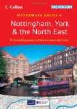
Nottingham, York & the North East (Collins/Nicholson Waterways Guides, Book 6)
Popular guide covering the canals and waterways between York and the River Trent south of Nottingham. Colour Ordnance Survey® maps clearly show locks, towpaths and boating facilities. There are also comprehensive navigational notes as well as descriptions of the towns and villages, pubs and restaurants alongside the waterways.
In print for over 30 years, the Collins/Nicholson guides to the waterways have always been a vital part of journeys along Britain's canals and rivers. They are designed for anyone and everyone with an interest in Britain's inland waterways - from experienced boaters to those planning their first boat trip, as well as walkers, cyclists and visitors.
The Ordnance Survey ® Maps have added information showing:
Locks, bridges, tunnels, aqueducts, winding holes and towpaths.
Waterpoints, sanitary stations, pump out facilities and refuse disposal.
Boatyards, pubs, restaurants and local shops.
Mile markers and milestones (distance in miles and number of locks to strategic points along the waterways).
Text includes:
The history and background to each canal.
Local services and places of interest, pubs and restaurants and NEW for this edition: postcodes added for each place.
Opportunities for walking and cycling.
NEW for this edition: notes on wildlife to be found along the waterways.
Comprehensive navigational notes include:
Maximum dimensions and low bridges.
Mileages, advice and potential hazards.
Navigation authorities and contact details.
Waterways covered in this guide - Aire & Calder Navigation, Chesterfield Canal, River Derwent, Fossdyke & Witham Navigations, River Ouse, River Ure and Ripon Canal, Pocklington Canal, Selby Canal, Sheffield & South Yorkshire Navigation, River Trent.
Price: £9.59
Publication: 1 Mar 2012 [Spiral-Bound]


York books: History & Heritage
1066: The Battles of York, Stamford Bridge and Hastings
If ever there was a year of destiny for the British Isles, 1066 must have a strong claim. King Harold faced invasion not just from William and the Normans across the English Channel but from the Dane, King Harald Hadrada. Before he faced the Normans at Hastings in October he had fought and defeated the Danes at York and neighbouring Stamford Bridge in September. What dramatic changes of fortune, heroic marches, assaults by land and sea took place that year! This book explains what really happened and why in what is arguably the 'best-known' but worst understood battle in British history.
Price: £9.99
Publication: 6 Jun 2002 [Paperback]


The York books listed on this page are for your information and to help you find the books you need quickly. We do not endorse any particular books and are not responsible for the advice and information in the books listed.
The price of books, where indicated, was correct at the time the book was added to this page. Prices may have changed on the booksellers web site.


