- UK Information
- UK Guidebooks and Maps
- Burton upon Trent books and maps
Burton upon Trent books and maps
Here is a list of books for Burton upon Trent that you may find useful.If you plan to travel to Burton upon Trent you may be interested in some guide books and travel books that will help you plan your stay in Burton upon Trent and to find your way around. Click on any book for more information or to buy.
Burton upon Trent books: Maps
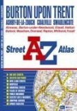
Burton upon Trent Street Atlas
This atlas of Burton-upon-Trent, Ashby-De-La-Zouch, Coalville and Swadlincote contains 38 pages of coloured street mapping extending to include:
Hatton, Hilton, Etwall, Tutbury, Rolleston-on-Dove, Willington, Repton (inset), Winshill, Stapenhill, Yoxall (inset), Barton-Under-Needwood, Church Gresley, Alrewas, Rosliston, Linton, Overseal, Whitwick, Donisthorpe, Measham and Ibstock (inset).
Postcode districts and one-way streets are featured on the street mapping.
The index section lists streets and selected flats, walkways and places of interest, place area and station names, hospitals and hospices covered by this atlas.
Price: £4.36
Publication: 28 Feb 2008

Derby and Burton Upon Trent (OS Landranger Map)
Perfect for day trips and short breaks, the OS Landranger Map series covers Great Britain with 204 detailed maps. Each map provides all the information you need to get to know your local area and includes places of interest, tourist information, picnic areas and camp sites, plus Rights of Way information for England and Wales.
Price: £5.24
Publication: 25 May 2009
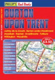
Philip's Red Books Burton Upon Trent (Philip's Local Street Atlases)
This local street atlas of Burton upon Trent, and its surrounding towns and villages, gives detailed coverage of the area at a scale of 4 inches to 1 mile. It also includes an enlarged centre map for Burton upon Trent at 7 inches to 1 mile.The maps show hospitals, car parks, post offices, one-way streets, leisure facilities, industrial areas and retail areas, while the index lists street names and postcodes. An area road map enables the user to identify through-routes more easily.Pocket sized, and wire stitched so that it opens out flat, the atlas is ideally suited for both business and leisure use, whether by locals or visitors.
Price: £3.50
Publication: 14 May 2008

The National Forest (OS Explorer Map): Burton upon Trent, Swadlincote, Ashby-de-la-Zouch & Coalville
OS Explorer Map is the Ordnance Survey's most detailed map and is recommended for anyone enjoying outdoor activities like walking, horse riding and off-road cycling. Providing complete GB coverage the series details essential information such as youth hostels, pubs and visitor information as well as rights of way, permissive paths and bridleways.
Price: £5.99
Publication: 21 July 2008
Burton upon Trent books: History & Heritage

A History of the County of Stafford: Burton-upon-Trent Vol 9 (Victoria County History S.)
This volume covers the town of Burton-upon-Trent on the county's eastern boundary, along with its suburbs and satellite villages on either side of the river, including Stapenhill which was formerly in a separate parish in Derbyshire. Best known as a major centre for brewing beer from the earlier nineteenth century, Burton first came to prominence in the early eleventh century as the site of a Benedictine monastery which later promoted the cult of its own saint, the legendary St Modwen. Part of the monastic infirmary survives in the present Abbey inn, and a house called Sinai Park on the high ground to the west of the town was used by the monks as a rest home and hunting lodge. Alabaster carving developed as a specialist industry in the middle ages, and clothworking was important until the nineteenth century, with fulling and then cotton mills on the river Trent. The breweries were concentrated in the historic town centre near the river, and in the later nineteenth century a more respectable centre was created to the west around the imposing St Paul's church and the present town hall, both paid for by members of the Bass family. Other Anglican churches built by leading brewers in the town and its suburbs remain a major feature in the landscape. NIGEL TRINGHAM is VCH county editor for Staffordshire, and lecturer in history at the University of Keele.
Price: £65.28
Publication: March 4, 2004
The Burton upon Trent books listed on this page are for your information and to help you find the books you need quickly. We do not endorse any particular books and are not responsible for the advice and information in the books listed.
The price of books, where indicated, was correct at the time the book was added to this page. Prices may have changed on the booksellers web site.